Prima’s expected departure from its Keppel Road flour mill in 2028 raises a key question for Singapore’s southern waterfront: what could take its place as the surrounding district shifts toward residential and commercial uses?
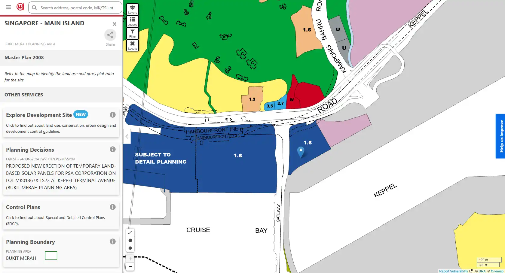
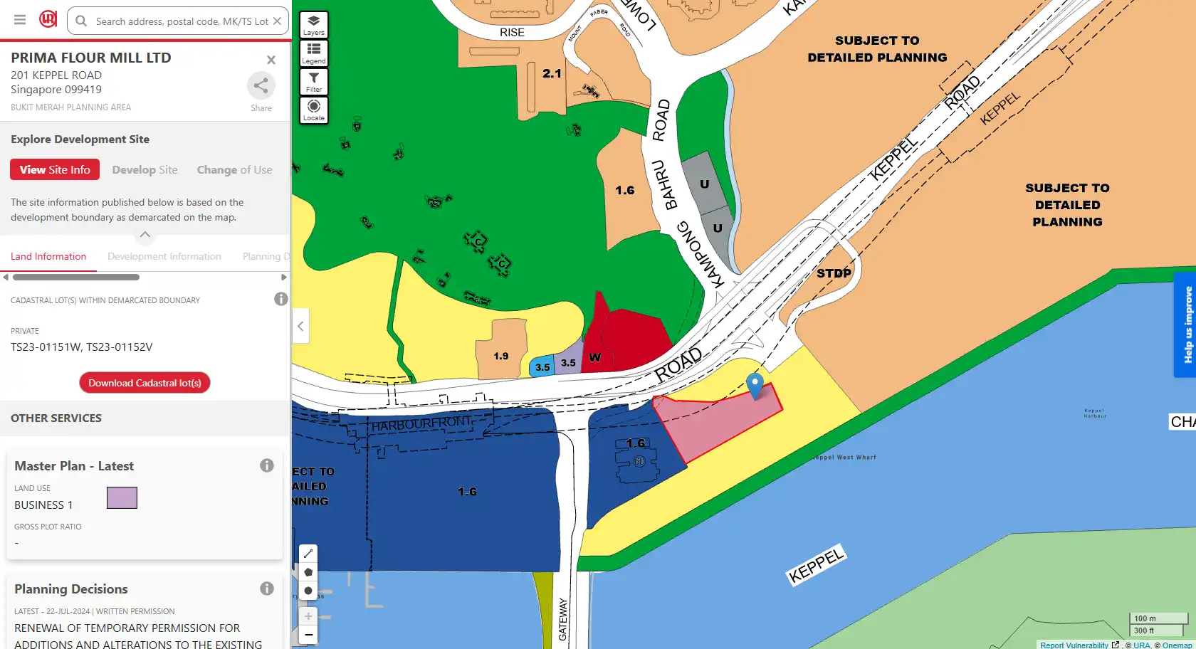
Comparing URA’s Master Plan 2008 with the recent planning map makes the transformation clearer.
In 2008, Prima’s mill sat within a broader industrial setting, with Business 1 zoning also covering the nearby Keppel Distripark area. In the recent map, substantial areas previously associated with industrial and port activities are shown for residential use, subject to detailed planning.
Prima’s own site remains zoned Business 1, with reserve land around much of its boundary.
The mill’s departure could therefore become another milestone in a transformation already visible on the planning map. But its future use, the treatment of its distinctive structures and the redevelopment timetable remain open questions.
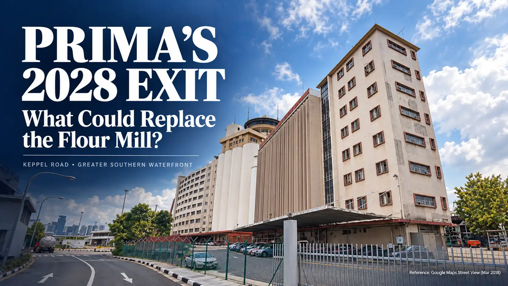
Prima’s expected departure creates an opportunity
According to The Business Times’ report dated 9 October 2026, Prima is expected to leave its historic complex at 201 Keppel Road when its extended tenancy ends.
Prima extended the lease by nine months, from 30 April 2027 to 31 January 2028, at its request.
Mapletree Logistics Trust owns the property. The report states that Mapletree Investments has a call option giving it the right to acquire the property from the trust for redevelopment.
Mapletree is exploring options for the site as part of the Greater Southern Waterfront’s rejuvenation, including conservation studies to assess opportunities for adaptive reuse.
This creates a basis for considering a new chapter for the property. However, the report has not announced a definitive replacement development or completion schedule.
What the 2008 Master Plan reveals
The historical map provides context that is easy to miss when looking only at today’s planning.
Under the 2008 Master Plan, Prima Flour Mill was one of the Business 1 sites in a wider industrial and port district. The nearby Keppel Distripark area across Keppel Road also carried Business 1 zoning.
The mill and Distripark were separate plots, but their industrial designations reflected the area’s established economic role. Warehousing, goods handling and flour milling belonged within the same port-oriented setting.
The recent map shows how substantially that context has changed. The larger former industrial area around Keppel Distripark is now shown for residential use, while substantial land around Keppel Terminal is also earmarked for housing, subject to detailed planning. URA’s Master Plan 2025 material identifies both Keppel Terminal and Distripark as future housing areas.
Prima’s Business 1 designation now stands out against this changing background.
That distinction matters: the surrounding district’s planning direction has shifted towards housing, while the mill’s own zoning has yet to follow that direction.
It would nevertheless be too broad to describe the entire HarbourFront–Keppel area as purely residential. The recent map still shows commercial land, reserve sites, parks and other uses, alongside Prima’s industrial plot.
St James Power Station shows how protection can evolve
The historical map also adds an important dimension to the comparison with neighbouring St James Power Station.
In the 2008 map, the St James site is shown as a commercial plot with a gross plot ratio of 1.6. At that point, it had not yet received the national monument designation it holds today.
URA records that the former St James Power Station was preserved on 11 November 2009, after the 2008 Master Plan.
This sequence demonstrates why a land-use map should not be treated as a permanent verdict on a building’s future.
Commercial zoning establishes a land-use framework. Heritage protection is a separate consideration that can be introduced subsequently and influence how a site is developed or adapted.
For Prima, the lesson is relevant. Its current Business 1 zoning does not require industrial use to continue indefinitely. Equally, the absence of a confirmed conservation decision does not establish that demolition will follow its departure.
The reported conservation studies leave open the possibility that some form of retention could shape the eventual proposal.
St James offers a nearby example of industrial architecture finding a new purpose, although Prima’s structures, condition and commercial possibilities would need their own assessment.
The surrounding reserve land could shape the outcome
The recent map shows reserve land around much of Prima’s plot. Its eventual treatment could shape how the site connects with the wider waterfront.
URA defines a reserve site as land whose specific use has yet to be determined. It should therefore not be treated as a confirmed future condominium, shopping centre or extension of Prima’s property.
From a planning perspective, however, this unresolved land creates scope to consider the area more broadly.
Future decisions could address pedestrian routes, public spaces, access arrangements and the relationship between the mill, St James Power Station and adjoining residential areas.
A coordinated approach could potentially create a more accessible and coherent neighbourhood than developing each plot in isolation.
That remains a planning possibility. The map does not confirm that the reserve land and Prima site will be combined or developed under one project.
What could replace the flour mill?
The surrounding shift towards residential uses makes a future change of use worth considering. Several broad outcomes are possible, subject to planning decisions and feasibility.
A new residential or mixed-use development could complement the planned housing areas nearby. However, such a proposal would require the appropriate land-use changes and approvals; neighbouring residential zoning does not automatically extend to Prima’s site.
Adaptive reuse is another possibility. Selected structures could potentially accommodate commercial, dining, cultural or other compatible activities, giving the future neighbourhood a recognisable landmark.
A third approach could combine retained structures with new construction. This would allow part of the complex’s identity to survive while creating more practical spaces elsewhere on the site.
Each option involves different challenges.
A mill and its silos were designed for industrial processes. Converting them for public or commercial occupation would require consideration of floor layouts, access, daylight, building services and structural suitability.
New construction offers greater design flexibility, but could sacrifice features that distinguish this location from other waterfront developments.
The relevant question is which approach can deliver a viable new use while responding to the site’s history and its changing surroundings.
Why 2028 is a milestone rather than a completion date
Prima’s expected departure provides a reference point for the next phase, but the historical maps show that district transformation unfolds over many years.
St James received its national monument designation after the 2008 planning map. Nearby industrial and port land has subsequently been earmarked for housing. Prima’s own future remains under consideration.
These changes occur through separate decisions and timetables.
After the mill is vacated, redevelopment could still depend on the intended use, heritage assessments, ownership arrangements, detailed design, approvals and coordination with neighbouring infrastructure.
The residential areas marked subject to detailed planning reinforce this uncertainty. Their overall purpose is visible, but the map does not establish final building layouts or delivery dates.
Prima’s end of tenancy should therefore be understood as a potential enabling step, not a promise that construction will begin immediately.
What this means for nearby property buyers
For buyers considering HarbourFront and the wider southern waterfront, the comparison between the two maps provides stronger evidence of the area’s changing direction than the relocation headline alone.
A district that previously accommodated substantial industrial activity is being planned to support more housing and urban amenities.
However, individual properties will experience that transition differently. Better connections and new amenities could improve neighbourhood appeal, while construction, additional development and altered views could affect particular homes.
The next meaningful signals will be a confirmed future use for Prima’s site, decisions on which structures to retain, detailed plans for adjoining land, and an implementation schedule.
The 2008 map helps explain where the area started. The recent map indicates where much of the surrounding district is heading.
Prima’s departure could help connect those two chapters. What replaces the mill—and how it fits into the wider neighbourhood—will determine the significance of that change.
Disclaimer: This article is for general information and commentary only and does not constitute property, investment or legal advice. It draws on publicly available reports and URA planning maps available at the time of writing. Comparisons between Master Plan 2008 and recent planning maps illustrate changes in land-use planning; zoning alone does not establish a building’s conservation status or confirm redevelopment approval. References to possible future uses, retention of structures and effects on nearby properties are analytical scenarios, not announced plans or guaranteed outcomes. Prima’s expected departure in 2028 does not confirm a redevelopment start or completion date. Planning designations, tenancy arrangements and development proposals may change and remain subject to relevant approvals. Readers should verify the latest information with URA, the property owner and other relevant authorities before making property decisions.
Article contributed by Jerry Wong.
 Jerry Wong is a realtor at Propnex Realty, bringing a rich background in interior and lighting design to his work. He loves exploring diverse spaces and observing the transformative power of real estate. Beyond his professional role, Jerry finds his greatest fulfillment in connecting people with the right properties, gaining immense satisfaction from helping clients achieve their dreams.